Objectives
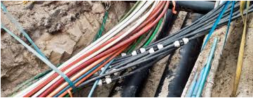
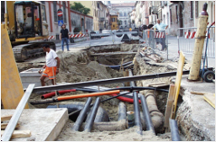
This Pilot consists in 4 use cases. The first one refers to an aspect of great political and strategic importance for the city of Genoa: The integrated management of the Utility networks.
In this context, GeoSmartCity plays an important role as driver for achieving an effective and efficient cooperation between the Municipality and the Multi Utility company.
The other cases are included in this strategic context and they refer to real operative tasks and more detailed actions using underground data that take advantage of this integrated work environment.
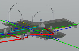
For the first time, and thanks to the GeoSmartCity HUB and the project Harmonisation resources, INSPIRE compliant data will be included in the city underground data management workflow.
Furthermore, other technological aspects of great interest will be added to the everyday underground network management work, like improved excavation procedures, the use of high precision outdoor positioning devices and the use of advanced visualisation techniques (such as 3D and Augmented Reality ) in mobile clients used on field works.
Comune di Genova
Palazzo TursiVia Garibaldi 9
16124 Genova
Italy
44° 24′ 39.4122″N, 8° 55′ 53.673″ E
Scenario
Underground